


Area Fact livability of places and neighborhoods
Find regional, geographical related data, information & statistics of local places and neighborhoods in the USA. Look for area specific information including demographics, cost of livings, crime rates, religion, taxes, housing and real estate information, climate, schools and public education, transportation, commute and job and employment. Find the best places to live, work, raise a family or retire.
A location can be specified using zip code, city, town, county or state name. It can also be entered by simply clicking on the background map, which conveniently display zip code boundary of places. After a position on the map is clicked, a selection box pops up to allow the further determination of which area in the location hierarchy to use - zip code, town/city, county or the entire state.
Demographic data mainly from the official US census, including resident population, area size, population density, distributions by gender, race, medium age of residents, medium age by gender, medium age by race, household count, size, composition, medium family income, income distributions, household age distributions, education background, marriage statistics, primary languages spoken, owner occupied vs. renter occupied homes, house ages, property tax rate, etc.
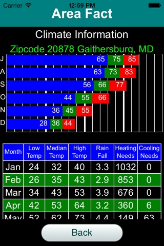
Climate includes the high, low, average temperatures as well as the amount of rainfall and number of days when heating and air conditioning are needed in each and every month and the entire year as a whole.
School data include school districts and list of schools. For each entry, there is the school name, address, type of schools (e.g., regular, vocational, special Ed, charter school and magnet school), grades offered, number of students, general rating and rating score by parents, etc.
Cost of livings information includes the national percentile, overall index and indices breaking down into subcategories like grocery, health care, utilities, transportation and miscellaneous expenses, etc.
Housing and real estate information includes data such as mortgage to income ratio, owner occupied homes percentage, number of rooms in a home, median house listing price, median sold price, listing price per square feet, number of houses for sale, recently sold homes, housing age distributions, property tax rate, etc.
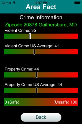
Crime information currently has indices of violent and non-violent (property) crime in the neighborhood. It will be expanded to include other data such as count of crime incidences and number of registered offenders, etc. in the near future.
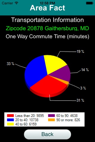
Transportation information contains statistics on ways of transportation to work for residents, which includes numbers of people using private vehicles, public transportation, bicycle/walk, work from home, etc.
Version 1.1 added a clickable map with zip code overlay for viewing and searching. When a location on the map is clicked, the user has a choice for picking a zip code, town or city, county, or the entire state as the target location.
Version 2.0 included a new "About" information category, which provides general descriptions about the local area. Such information may include the history of the region, local climate and geographic characteristics, school systems, etc. It has enhanced information for the public education, such as ratings of local schools. It also has improved location detection algorithm and allows re-positioning of background map to users current location.
Version 2.1 includes the new "Religion" category, currently supports retrieving churches information including name, address and church denomination. It will be expanded to include other religious information in the near future.
Version 2.2 adds "Employment" category showing job and employment related information and data in local areas. Currently it has data of total numbers of employers and employees, first quarter and year end payrolls numbers. These information are from the 2014 census, which is from the latest data published by the US census bureau.